Velebit – Paklenica: A Mountain Trail for Connoisseurs
Velebit – Paklenica: On the Edge of Civilization
A Croatian mountain adventure for connoisseurs spans 52 km of trail, with 2 kilometers of ascent and nearly 3 kilometers of descent.
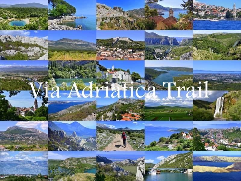
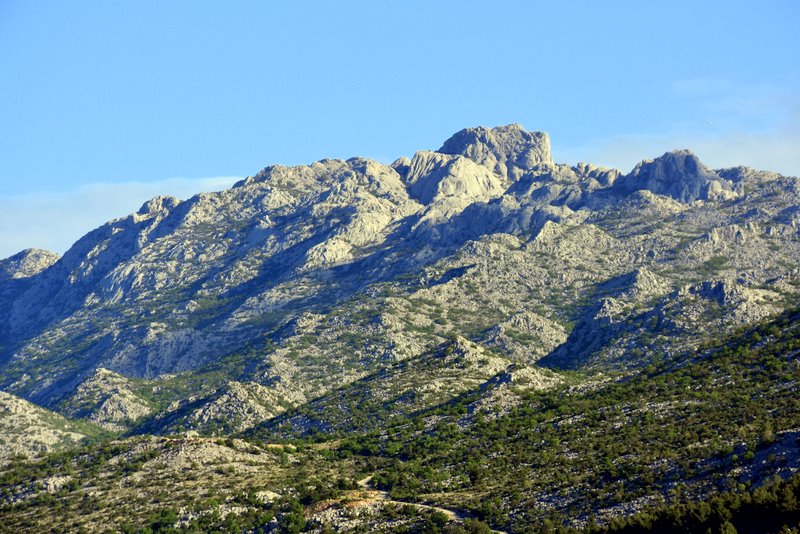
The Velebit mountain range in Croatia stretches over 160 km along the Croatian coast. Although the highest peaks in this range reach just above 1300 m above sea level, they appear striking from sea level. The trail described below partially overlaps with the Via Adriatica Trail, which connects the two most distant points of Croatia in an 1100 km mostly mountainous trek featuring 42 km of ascent and roughly two months of very demanding walking.
I had looked at these mountains many times, each time feeling a strong urge to touch the rocks so clearly visible from the islands of Pag and Vir, the town of Nin, and Zadar. The desire for close contact with the mountains grew until I finally decided that this time, instead of exploring cities (which are also very attractive), I would make a targeted trip to Croatia focused on mountain hiking.
Low-cost Irish airlines make budget travel to Croatia feasible, and as soon as a favorable price matched my desired dates, the decision was made. I bought the tickets well in advance, giving me plenty of time to assemble my gear. This was significant because the time of year was unpredictable, and the trail lay beyond civilization. Setting out on the section where the international Highlander hike takes place, I had to be prepared to carry all gear and provisions for several days of trekking on my back.
Water was not as readily available as suggested by maps; during the hike it became clear that water existed only at designated camping points, specifically in the huts run by the Croatian Mountaineering Society HPD “Paklenica” from Zadar. Preparing for this trek, I aimed to be self-sufficient in the field while also paying attention to gear weight and essential equipment. On shorter trips this is less critical, but for the over-50 km stretch ahead with many ascents, descents, varied terrain, and significant weather and temperature changes, careful preparation was necessary.
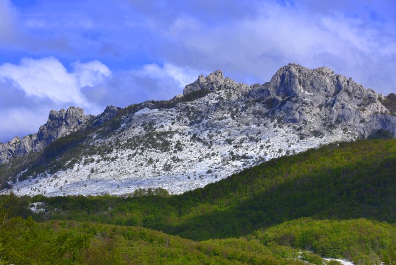
Mother Nature added her own challenge right at the start by dumping a lot of snow the night before departure. So, instead of the expected warm Croatian April weather, I encountered winter conditions with cold winds and sometimes hail mixed with rain.
Day One: Baške Oštarije to PS Šugarska Duliba
Daily Distance (per Wikiloc): 14.73 km
Ascent: 871 m
Descent: 593 m
The starting location is in Baške Oštarije, beside a small hotel and a seasonally open restaurant. We were driven there by Marin Marasović, who runs a small hotel in Starigrad Paklenica and organizes photo safaris. From the campsite to this point, the road winds along the coastline and takes approximately 1.5 hours.
In Karlobag, just before turning onto the mountain road, there is a small gas station—your last chance to buy drinks or other small items. From there, a scenic 19-kilometer climb begins, winding up from sea level to over 900 m above sea level. At last, the moment came to begin into the unknown.
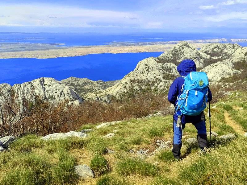
Initially, the trail follows a well-worn path, which for casual hikers ends a kilometer higher at a viewpoint overlooking the rock massif left behind. Minutes then hours passed as we walked a very varied trail through forests winding between trees and rock outcrops, meadows between hills, and slopes strewn with rock debris. Such places demanded occasional breaks and, of course, photographs. There were first exclamations of awe—and this was only the beginning of the adventure in this part of Velebit.
Occasionally glancing at the Adriatic islands and coastline in the sun, a touch of envy emerged. There, warmth and sun; here, cold wind and snow underfoot. My rain jacket and down layers, far from lying idle in the bottom of my pack, worked hard on this trip. Unfortunately, I did not bring gloves, which in mid-April in Croatia seemed unnecessary at the time, but proved to be a small mistake. With trekking poles, gloves would have been very useful. But onward we went—there was much distance to cover.
After five hours of walking, the scenery changed. Forest paths gave way to open spaces under approaching dark clouds. The temperature dropped, encouraging us to walk without stops, as conditions were not inviting for rest. Hail with rain helped maintain a brisk pace. We passed two other backpackers, as if released from the jungle and equally laden.
This brought us to our first overnight stop. Šugarska Duliba, a hut in the middle of nowhere, surprised us very positively. Inside it was quiet and empty, but well equipped with a sink and water (rainwater collected into a container under the floor), a stove with prepared firewood, hanging beds, and even electricity from solar panels sufficient to light the interior and charge phones. The hut is well maintained not only by the mountain club from Zagreb but also by all users. The toilet was a traditional outdoor facility built a few meters away between the rocks. Everything made it possible to avoid pitching the tents we carried in our backpacks.
The tranquility was slightly disturbed by two young people from Slovenia who, like us, had decided to take on Velebit before the season. A pleasant conversation followed, along with an exchange of plans for the coming days. They were finishing a crossing of the entire Velebit, and we were somewhere in the middle.
Until morning came.
Day Two: PS Šugarska Duliba to Tatekova Koliba
Daily Distance (per Wikiloc): 11.86 km
Ascent: 422 m
Descent: 747 m
The terrain’s character and the lack of access to water or other suitable overnight sites essentially forced us to choose a shorter route for this day. The trail leads from hut to hut, and although the distance is not great, it takes more time to traverse. We also spent more time taking breaks because there were many scenic locations. Behind us stood additional mountain peaks, and 1200 meters below spread the expansive Adriatic coastline with many islands. At times, the Italian coastline was visible.
This segment’s terrain was mostly rocky and overgrown, requiring careful navigation. As a reminder, this is not a trail traveled daily by crowds. It lies far from civilization and any comforts. To descend to the nearest town would require several hours, mostly along paths more frequented by animals than people. Not without reason, a few kilometers ahead we encountered the ruins of a former radar base and a multi-level bunker carved into the mountain. We reached this site by chance after several hours of hiking, arriving at a forest road marked by a heavily shot sign commemorating the difficult times of the breakup of Yugoslavia.
Exiting the forest, we saw a mountain ridge with clearly visible concrete posts of an old fence. With a slight detour from our route, we arrived at the abandoned Panos military base. Touring this site offered spectacular views of the vast mountains on one side and the coastline with islands extending to the horizon on the other. The detour was absolutely worthwhile—coffee in such surroundings tasted exceptional. The weather was favorable, and the day’s segment was not demanding, allowing us to continue without rush.
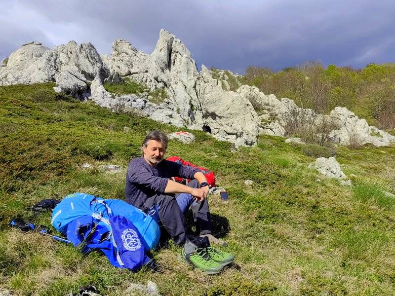
A few kilometers later, we entered a forest, following a winding trail that led to a broad mountain pass. Surrounding rocks became increasingly varied and slender, and eventually we reached a large hollow where another hut awaited.
Descending lower, we wondered whether the hut would house a few people or many. We arrived at a cabin nestled among greenery and towering rocks. It turned out the hut was again completely empty. The sun was still high enough that we prepared lunch outside in the company of many singing birds. For me, this place was like paradise. Inside the hut was a stove and prepared wood, and solar panels provided light and the ability to charge phones. A short distance away, next to a large rock, stood a hand pump. It required several strokes before water came, but when it did, it was true spring water from the mountain: cold and tasty. For a toilet, a shovel was provided, and one had to venture away from the hut and water source to find a suitable spot.
Evening by a warm stove and wind outside. Only at night did animals make noise, trying to get inside. But after all, this is far from civilization and wildlife is at home here. We were guests on their turf.
Morning of the third day dawned with the longest segment planned. Quick coffee, refill water supplies, and we were off.
Day Three: Tatekova Koliba to Starigrad Paklenica
Daily Distance (per Wikiloc): 25.16 km
Ascent: 715 m
Descent: 1,564 m
The trail did not begin gently; from the first meters there was a steep ascent with rapid elevation gain. Ahead lay the most varied terrain and diverse trail markings. At intersections, there are usually signs indicating directions, destination names, and estimated times. The trail itself is marked with a white dot in a red circle, often simply a red stripe on stone.
The initial kilometers allowed us to follow these markers, but further on—especially across expansive valleys—navigation became essential. After checking many maps, the best proved to be https://pl.mapy.cz
. This segment of the trail is interesting, as it traverses hills, valleys, meadows, forests, pastures, a small settlement, and even passes beside a farm with a large though seemingly friendly dog. Whether it was friendly only to us remains uncertain.
Velebit, Chorwacja, odcinek z Baške Oštarije do PS Šugarska Duliba - Tatekova Koliba - Starigrad Paklenica
https://pl.wikiloc.com/wikiloc
Base and Logistics
Base Camp
A base camp I used was Camp Nacionalni park, a campsite located next to the Paklenica National Park administration building and right by the beach, mainly used by hikers, climbers, and park enthusiasts. The campsite operates from mid-March to mid-November and does not accept reservations. It can accommodate around 90 people, offers electrical hookups, partial shade, and well-maintained sanitary facilities. Grocery stores, restaurants, and cafes are nearby. Nacionalni park Paklenica+1
Travel Options
By Car: Many travelers from Poland drive to Croatia. With a group and shared costs, round-trip expenses including fuel and tolls generally total around 3,000 PLN. When driving from Poland, remember to purchase vignettes for each transit country. Regardless of whether you route through Hungary or Slovenia, in Croatia the route via Rastoke and the Plitvice Lakes is recommended as a pleasant path with scenic stops.
By Air: I chose to fly, and traveling as a pair, we managed to keep costs around 700 PLN. Finding cheap tickets was straightforward with two months’ lead time. For example, we booked Kraków–Zadar tickets for 104 PLN per person plus a 20 kg checked bag for 134 PLN one way. We managed to pack two backpacks with all our gear into a single 160 L bag. Total round trip for two people with checked luggage was 684 PLN.
Local Transport: From Zadar Airport to Zadar Central Bus Station, regular buses run (hourly off-season and every 30 minutes in season). From there buses run in various directions. A ticket to Starigrad Paklenica costs about 6.40 euros. For greater flexibility, we rented a car, which facilitated night transfers from the airport to the campsite and independence in exploring the wider area. Nine days of car rental with full insurance and no hidden fees cost 250 euros, plus fuel costs—our car consumed about 6 L/100 km.
Important Notes
From the start at Baške Oštarije to Starigrad Paklenica there are no water refill points except for the rainwater tank at PS Šugarska Duliba and the hand pump near Tatekova Koliba. There are no rivers, ponds, or other opportunities to refill water, which must be taken into account before setting out.
Wild camping in Croatia is heavily restricted and often results in significant fines. Before camping with a tent anywhere in Croatia, verify the regulations for the area you plan to visit.
opracowanie & foto: Albin Marciniak
https://www.facebook.com/marciniak.albin
#Chorwacja #Croatia #Velebit #Paklenica #góry #mountain